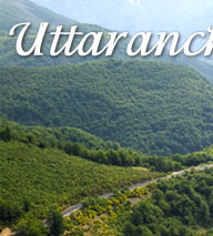
Uttaranchal
Tourism –» Mussoorie
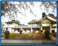
Mussoorie, Uttaranchal Hill Station
 Mussoorie,
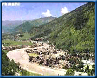
Popularly known as the Queen of Hills, this charming hill station, 34 kms from
Dehradun is situated at an altitude of 2003 mts in the Garhwal hills. above
sea-level. Mussoorie is one the beautiful hill stations in India and the most
frequently visited. It provides excellent respite to people who want relief
from the hot sultry conditions of the plains, especially since it is close enough
to the capital to make just weekend trip. Also, major Hindu pilgrimage sites
like Kedarnath, Badrinath, Gangotri, Yamunotri, Haridwar, Rishikesh are not
far from this place.
In 1820, Captain Young of the British army was influenced by the beauty of this
place and made it his residence. The name, Mussoorie is derived from plants
of 'Mussoorie' which were found in abundance here. After its discovery, this
hill station gradually developed as a centre of education, business, tourism
and beauty.
Mussoorie (Places to See)
Gun Hill
Enjoy a Ropeway ride to the second highest peak of Mussoorie. It can also be
negotiated by bridles path which forks-off from Mall Road near Kutchery and
to reach takes about twenty minutes. The Ropeway distance is only 400 mtrs.
And the sheer thrill of the ride is memorable. Gun Hill offers a beautiful panoramic
view of the Himalayan ranges namely Bunderpunch, Srikantha, Pithwara and Gangotri
group etc. and a bird's eye view of Mussoorie town and Doon Valley. During pre-independence
days a gun mounted on this top used to be fired heralding mid-day to enable
people to adjust their watches and hence this name.
Municipal Garden
A picnic spot having a beautiful garden and an artificial mini lake with boating
facilities. It is located at a distance of 4kms by cycle rickshaw, pony or by
car and only 2 kms on foot via Waverly Convent Road.
 Childer's
Lodge
Childer's
Lodge
Highest Peak of Mussoorie near Lal Tibba. It is about 5 kms from the Tourist
Office and one can go on horse back or on foot. Snow view from this spot is
exhilarating.
Camel's Back Road
It starts from Kulri Bazar near Rink Hall and ends at Library Bazar covering
a total distance of about 3 kms. The main charm of this froad is horse riding
and wlking. Sunset view of the Himalayas is superb. Camel's Rock with a life
like resemblace can be seen from the spot near Mussoorie Public school.
Jharipani Fall
8.5 kms from Mussoorie on Mussoorie- Jharipani Road. Visitors can go by bus
or by car upto 7 kms to Jharipani from where the fall is 1.5 kms, on foot.
Bhatta Fall
7 kms from Mussoorie on Mussoorie-Dehradun road. Access by car or bus upto Balta
village from where the fall is 3kms by car or foot. An ideal spot for bathing
anf picnics.
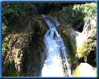
Kempty Fall
15 kms from Mussoorie on the Yamunotri Road having an altitude of 4500 ft. It
has the distinction of being the biggest and prettiest waterfall located in
a beautiful valley and is surrounded by high mountains. Bath at the foot of
the falls is refresshing and enjoyabled for children and adults alike.
Nag Devta Temple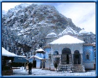
An ancient temple situated on Cart Mackenjie Road and is about 6 kms from Mussoorie.
Vehicles can go right upto the spot. It Provies a charming view of Doon Valley
as well as of Mussoorie.
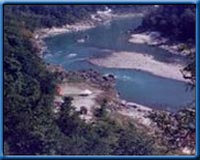
Mussoorie Lake
A newly developed picnic spot, situated on Mussoorie- Dehradun road and
is about 6 kms from Mussoorie. It is a delightful spot. Pedal boats are availble.
It commands an enchanting view of Doon Valley and nearby villages.
Van Chetna Kendra
At a distance of about 2 kms on Tehri bye pass road, this place is developed
as a picnic spot and has a park surrounded with pine forest and flowering shrubs,
and is approachable by foot or taxi/car. The main attraction is the wildilife
of the park like Ghurar, Kanankar, Himalayan Peacock, Monal etc.
Sir George Everest House
6 kms The Park Estate of sir George Everest, First Surveyor General of
India, Who had his offce and residence here, is approachable by road. The highest
peak in the world, Mount Everest, is named after him.
Jwalaji Temple (Benog Hill) 9 kms 6to
the west of Mussoorie and at an altitude of 2104 mtrs. Is the Jwalaji Temple.
It is situated on the top of the Benog Hill and has an idol of Mata Durga in
it. The temple is surrounded by thick forests and offers a panoramic view of
the Himalayan peaks, Doon valley and Yamuna valley.
Clous End
The bungalow built in 1838 by a British Major was one of the First Four buildings
of Mussoorie. The bungalow has since then been converted into a hotel called
Clouds End, and is situated at the extreme west of Mussoorie Hill, 8 kms from
Library. The resort is surrounded by thick forest, offers a wide variety of
flora and fauna besides a panoramic view of snow clad Himalayas, and Yamuna
river. The most ideally suited resort for fireigners and honeymoon couples.
Mussoorie (Institution)
Rich
in history and beauty, Mussoorie has given birth to many institutions that are
known virtually all over the country. Since 1959, the Lal Bahadur Shastri National
Academy of Administration has been training and molding batch after batch of
raw probationers into the country's finest bureaucrats, foreign service officers,
and police officers. the Academy, situated at Charleville, continues to train
officers for the Indian Administrative Service and the Indian Police Service.
A fire broke out in the Academy some years ago and destroyed, among other buildings
and papers, its precious library rated amongst the best in the country. While
many of the books destroyed in the fire are difficult to replace, a new beginning
has already been made by acquiring a fine collection of books.
While the Academy belongs to the post-Independence period, most of Mussoorie's
institutions date back more than a century. The Waverley Convent, a school for
girls, was established in 1845 and has commemorated 150 years of distinguished
existence. While some of its buildings were destroyed in an earthquake in the
early years of this century, then by a fire, and then again in the recent earthquake,
Waverley still retains much of the old-world architectural charm. The cable
cars swing between the Hall and Gun Hill more than 100 times a day.
Mussoorie (Excursion)
Naga Tibba
About 55km, an ideal spot for trekking. Naga Tibba is the highest peak around
Mussoorie at 10,000 feet and is covered by thick forests.
Dhanolti
On Mussoorie-Tehri Road 25km away, it has deodhar forests and mountainscapes.
Surkhanda Devi
Surkhanda Devi Temple at 10,000 feet, 35 km down the Mussoorie - Tehri road.
Perched on a peak, the temple demands a stiff two-km climb form devotees. The
temple, goes the legend, was built on the site where the head of Shiva's consort
(Shiva is the destroyer in the Hindu trinity) fell after it was chopped off
to stop Shiva's terrifying dance of death that was shaking the universe to its
very core.
Lakha Mandal
80 km away on the Mussoorie-Yamunotri Road. Linked with the Mahabharata
with idols of archaeological importance.
Mussoorie (When to visit )
Mussoorie
is a hill station which has pleasant climate around the year. It is a very cool
place with greenery at its full bloom during September to November. The best
seasons to visit Mussoorie is between April to June and again during September
to November. When the plains of North India experience heat waves, Mussoorie
provides a welcome break. September - November is spring time here. During this
season Himalayas are clearly visible. It is better to avoid monsoons as the
roads to Mussoorie are in bad shape. Same thing applies for the winter when
roads are blocked due to snowfall
Mussoorie (Travel Information)
There are regular flights from Delhi to Doon Valley (Jolly Grant). From the
Jolly Grant airport, taxis and buses ply to Dehradun, from where they go up
to Mussoorie (2¼ hours, 60 km).
The overnight Mussoorie Express links Delhi to Dehradun, the railhead for Mussoorie.
Delhi to Mussoorie is 290 km by road. Dehradun to Mussoorie is 35 km. There
are direct buses from Delhi to Mussoorie, along with private taxis. Buses ply
every half hour from Dehradun to Mussoorie. Private taxis and shared taxis are
favored by a majority of visitors.
Mussoorie - Local Transport
Hand pulled rickshaws, taxis and cars are not allowed on the Mall, but
can move in other motorable parts of Mussoorie.
Mussoorie (Accommodation)
Mussoorie has more than a hundred hotels to choose.
Mussoorie (What to Wear)
In summer, light woolens are advisable while heavy woolens are a necessity
during winter.
The summer season extends from April to June. The winter season is from September
to December.
Area : 65 sq km
Altitude : 2005.5 m
Temperature in Summer : 31.2°C(max);7.2°C(min)
Temperature in Winter : 7.2°C(max);1.1°C(min)
Languages : Hindi and English
Best Time to Visit : April-June and September-October
Mukteshwar, Uttaranchal Hill Station
At
a distance of 52 km. from Nainital, Mukteshwar set atop a high ridge, is a beautiful
Himalayanresort. Surrounded by fruit orchards and thick coniferous forest, it
provides a majestic view of the Himalayas and the Almora town below in glittering
moonlit nights. The famous Indian Veterinary Research Institute is also located
here.
Sightseeing
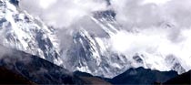
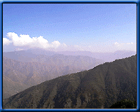
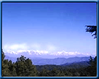
The View of Himalayas
Mukteshwar provides a panoramic view of the magnificent Himalayas. This splendid
view has been a great attraction to the visitors
Indian Veterinary Research Institute
The Institute, well known for its contributions in the research relating to
animals, is located here
Excursions
Ramgarh : 26 km. A picturesque hamlet in the heart of apple, plum,
peaches and apricot orchards. This fruit belt of Kumaon is famous for its juicy
fruits all over India.
Bhowali : 40 km. Situated at an altitude
of 1706 mts. on the main Haldwani-Almora road, Bhowali is a popular health resort.
Ghorakhal : Ghorakhal 37 km. Famous for
the temple of Gollu Devta, a demigod highly revered by the Kumaonis.
Pithoragarh, Uttaranchal Hill
Station
The
famous hill station Pithoragarh is in Uttaranchal, which seems to be attracting
a lot of tourists these days, because the state not only offers the tourists
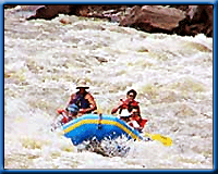
a chance to enjoy natural beauty but also a chance to try various adventure
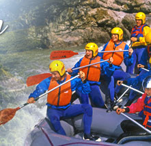
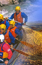
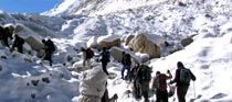
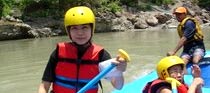
sports, such as white river rafting, hang-gliding and skiing. So whether you
want to spend a holiday close to nature or have the time of your life. Come
to Pithoragarh and make Hill resorts in India your travel partner, so you can
choose the right holiday package to this beautiful hill resort.
Location Pithoragarh stands at a height of 1,851 meters in a valley, fondly
called the 'Little Kashmir' in the northern state of Uttaranchal. The district
covers an area of 8,856 square kilometers and it borders both Nepal and Tibet.
Places to Visit
While you are at a tour of Pithoragarh, you can check out a number of lakes
around Pithoragarh. There are two of them which are quite famous, one of them
being
Jolingkong and the other one being
Anchherital. While the
former is at a height of 4,634 meters, the latter is situated at an altitude
of 3,658 meters. The district is dotted all over with many old temples that
you visit. There is a shrine at
Purnagiri, which is only 20 kms from
Tanakpur, and there is another Sikh shrine near
Lohaghat called
Ritha Sahib. According to a belief, Guru Nanak touched the bitter ritha
and it turned sweet after his touch.A tour to the
White Manu Temple is
also a must if you are in Pithoragarh. It is dedicated to the Goddess, who on
invocation brings rain thus good fortune to the mountains.
Excursion
If you are in Pithoragarh for a few days, you can travel to Baleshwar, which
is 76km away on the Tankpur Road. There you can see the beautiful temples which
were built by early Chand rajas in the 8th Century. About 77 kms from Pithoragarh
is a Shaktipeeth, which was established by Adi Sankaracharya. About two kilometers
away is Chamunda Devi temple.Around 14 kms from Gangolihat is Patal Bhubaneshwar,
a temple, which is dedicated to Lord Shiva. Interestingly enough, one has to
go through a tunnel to reach the temple.Around 62 kms from Pithoragarh is Lohaghat.
About 2 kms from here is the Abbot Mount and Mayawati. At Mount Abbot, one can
see a lot of Bungalows, which belong to the colonial era. This place also offers
a great view of the Northern Hill Ranges. Mayawati is known for the headquarters
of Adwait Ashram. At a distance of 7km from Pithoragarh is Chandak. It is at
a height of 1,830 meters and offers a breathtaking view of the Pithoragarh valley.
20 kms from Tanakpur is Punyagiri, which has the Punyagiri temple, which is
devoted to Maa Punyagiri.
 Mayawati
Ashram
Mayawati
Ashram
22 kms. from Champawat and 9 kms. from Lohaghat, this ashram is situated at
an altitude of 1940 mts. Mayawati shot into prominence after the Advaita Ashram
was established here. The ashram attracts spiritualists from India and abroad.
Abbot Mount
11 kms., Remarkable for scenic beauty Abbot Mount is situated 8 kms. from Lohaghat.
The place is famous for peaceful secluded holidays .
Devidhura
45 kms from Lohaghat Devidhura is famous for its Varashi temple, where the traditional
Bagwal (organised stone throwing between two grops) is held once every year
on Raksha Bandhan.
Vanasur - Ka - Kila
This fort is situated at an elevation of 1859 mts., 7 kms. from Lohaghat and
20 kms. from Champawat. (Lohaghat to Karnakarayat is 6 kms. by bus and Karnakarayat
to Vanasur-ka-Kila 1 km. by foot .
Visiting Pithoragarh
There are frequent buses to Pithoragarh from Almora, Nanital and Delhi, so getting
to Pithoragarh by road is no problem.The closest railhead is at Tanakpur and
the closest airport is at Patnanagar, which is 249kms from Pithoragarh.
Lansdowne, Uttaranchal Hill Station
Lovely
Lansdowne, set at an altitude of 1,706 metres about 81 kms from Pauri is one
of the quietest hill station in the country. It was very popular among the Britishers
and is named after Lord Lansdowne, the Viceroy of India from 1888 to 1894. The
charming resort surrounded by thick oak and pine forest is a perfect place for
a peaceful holiday in the lap of mother nature.The Lansdowne was founded by
‘Lord Lasndowne’ in 1887 A.D., thus the place has been named after
him. Lansdowne was originally a popular hill station with the Britishers. Lansdowne
was a major place of the activities of freedom fighters from British Garhwal
during British period. Nowadays, the famous Garhwal Rifles of the Indian Army
had its command office here. 81 km. from Pauri, Lansdowne is situated at altitude
of 1,706 meters on a hill, which was originally known as ‘Kaludanda’
in local language, enroute Kotware-Pauri road. The nearest railway station is
Kotdwar at a distance of 41 km.
Lansdowne is a Military station developed by the Britishers, which is catering
for the Recruits Training center of the Garhwal Rifles. The war memorial at
the Parade Ground of the Garhwal Rifles Center is an attraction for the visitors.
Area of the city is about 6.09 sq. km. Total population as per 1991 census is
7,106 with 4,415 male populations and 2,691 female population. The literacy
percentage of the city is 89.58. The climate of the city is pleasent in summer,
very cold in winter. The nearest airport is Jollygrant, a place near to Deharadun
at a distance of 152 km. via Kotdwar-Haridwar road.
Surrounded by thick Oak and blue Pine forests, Lansdowne is a very charming
place for a quiet holiday as it is devoid of the usual hustles and bustle of
hill stations. Lansdowne has scenic beauty and good surroundings. The pine and
oak trees provide an healthy climate. The beautiful and refreshing points around
the city are Tip-n-Top, Santoshi Mata Temple, Church Point. The excursions from
the city are Tarkeshwar Mahadev temple, Bhairav Garhi temple etc. Annual ‘Shardotsav’
is also organized at this hill station during autumn season.
Facilities
Accommodation : Tourist Rest House and Hotels
Supplementary Accommodation facilities : Forest
Rest House, Army Welfare Board Rest House, PWD Inspection House.
Hospitals : Board Hospital &
Army Hospital.
Places Around Lansdowne
Situated 45 km from Lansdowne, Kotdwar is a gateway to the hills and one of
the last rail termini for Garhwal.
Karnva Ashram
The ancient ashram is located 14 km from Lansdowne. Legend has it that Shankuntala
gave birth to prince Bharat here, after whose name the country is called Bharat
Varsh. Other nearby places of interest include Sidhbali Temple (3 km) and Charaik
Hills (20 km).
Jwalpadevi
(52 km) Is one of the better-known religious areas of the entire division on
the main Pauri-Kotdwar road. A large number of devotees come here during Ashtami
(April and October) for pilgrimage.
Tarkeshwar Mahadev
(30 km) Is a temple of Lord Shiva situated at an altitude of 2092 m, on top
of a hillock surrounded by a thick forest of deodar, blue pine, and oak. The
temple is among one of the oldest in the world. The highlight of this place
is that even at an altitude of 2092 mtr.
How to Reach
By Rail : The nearest railhead for Lansdowne
is Kotdwar (2 hours), which is well connected by buses. Lansdowne is also linked
by a motorable road to almost all the important cities in Uttaranchal. Lansdowne
is 295 km from Delhi, 95 km from Haridwar and 150 km from Dehradun.
Ranikhet, Uttaranchal Hill Station
 Ranikhet
(The Queen's Field) has come to be known so because according to popular belief,
this spot had won the heart of Rani Padmini, Queen of Raja Sudhardev and she
chose this scenic spot to be her abode.To view nature & its elements in
full harmony, the right place to be is Ranikhet. It is the place which wonderfully
mirrors the best of the heavenly Himalayas offering excellent views of the snowcapped
Nanda Devi (7817m), lush green forests, delicate plant life and attractive wild
life.
At on altitude of 1829m, north of Nainital (61 km) and well connected to Almora
(44km) & Kathgodam (83km), Ranikhet ( km) has emerged as a favoured all
season destination. During the rains, flowers sprout up everywhere in rainbow
colours, branches of trees stoop with ripened fruits & sunlight peeping
through the mist & clouds endow an enchanting effect all across Ranikhet.
As winter comes, the softly falling snow flakes cover the environs in sheets
of pure whiteness.The 1869 the land was bought by British from local villagers
and a summer rest & recreation settlement was set for British troops. Today
it is an important army town and the head quarters of the Kumaon Regiment.
There are many enjoyable walks, picnic spots, exciting treks and 6km from
the town, Upat, has one of the best mountain golf links (9 holes) in the country
surrounded by dense oak forest. The Museum &c the Memorial are the jewels
of Ranikhet.
How to Get There
Air : Nearest airport is Pant Nagar, (119km)
Rail : as with the other hill stations in
the Kumaon Region, Kathgodam (83 km) and Ramnagar (96km) are the nearest railheads.
Road : Ranikhet is connected by road with
all the major towns of the region. There are regular buses to Almora, Nainital
& Ramnagar operated by KMOU & State Roadways, - 20643. It is also well
connected to Delhi (279km), & Haridwar (254 km).
Places to Visit
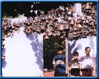 Jhoola
Devi Temple
Jhoola
Devi Temple
This secluded temple dedicated to Durga has beautiful bells, echoes of which
can be heard from some distance. Nearby is a temple of Lord Rama.
Chaubatia
Chaubatia is a vantage point set amidst gardens. The Government Fruit Research
center is located here. On a clear morning a 300 Km wide view of the snow -
clad Himalayan peaks can be seen clearly from Chaubatia, 10 Km from Ranikhet
on a motorable road. The Nanda Devi, Trisul, Nanda Ghunti and Nilkanth peaks
are very clear. Bhaludam, 3 Km from here, has an artificial lake.
Upat & Kalika
Situated on the road to Almora, Upat has a 9 - hole golf course, while Kalika
is famous for its Kali Temple and forest nursery.
TOUR ENDS WITH SWEET MEMORIES TAKE HOME
Uttaranchal Hill Stations Reservation Form